Geo-Yanomami reveals the impact of deforestation on indigenous territory
OCT 2 2023
A study with support from the HARMONIZE project brings unprecedented data on the occupation of the Yanomami Indigenous Territory by mining and deforestation; researchers hope the findings will help improve the strategy to support the Yanomami.
The Yanomami Indigenous Territory (TIY) humanitarian crisis gained global attention in early 2023. The image of malnourished children inside the reserve shocked the international community and served as a warning about a situation going on for more than a decade. The increase in illegal mining activities within the TIY has caused contamination of water and fish, the primary source of subsistence, in addition to causing outbreaks of malaria, hunger and violence against indigenous people.
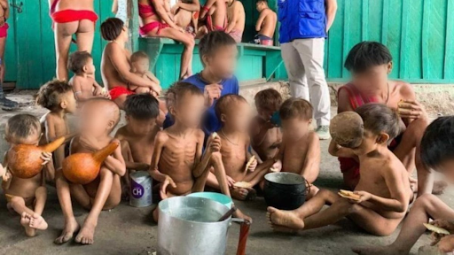
Hunger among Indian children. Photo: URIHI - Associação Yanomami, 2022.
A study conducted by the Geo-Yanomami working group, mainly composed of members of the HARMONIZE project, revealed that, in addition to mining, the Yanomami are dealing with another serious problem on their lands: deforestation caused by the expansion of the agricultural frontier. Researchers from the Oswaldo Cruz Foundation (Fiocruz) and the National Institute for Space Research (INPE) led the working group to consolidate spatial data and, in the future, assist in emergency actions in the field. The survey also involved scientists from the Veiga de Almeida University (UVA), the University of Brasília (UnB) and the Federal University of Amazonas (UFAM), among other institutions.
The group produced a situation report that provided an understanding of how environmental changes, migration and mining invasions were affecting the health conditions of the indigenous people. The report was reworked by the Infoamazonia group (a HARMONIZE partner for scientific dissemination) and had major repercussions in Brazil's major newspapers.
The researchers mapped how forest degradation and deforestation have advanced in TIY in recent years. Unlike deforestation, which is the total elimination of native vegetation in a given area, forest degradation is the partial and gradual elimination of vegetation in a process that can occur, for example, with selective logging, fire, edge effect and dry climate conditions.
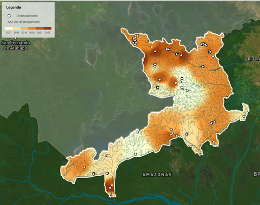
Deforestation trends in the Yanomami Territory. Dark areas depict recent deforestation activities.
“Although indigenous lands are one of the best barriers against deforestation, they are permeable. What changes is the time it takes to penetrate. When you have a government that for years tried to legalise mining and gave approval to activities that promote deforestation, you have an acceleration of this process”, explained Ana Rorato Vitor, coordinator of the deforestation analysis of the Geo-Yanomami group and researcher at the Research Laboratory in Socio-Environmental Systems (Liss) at INPE.
The mapping of these areas indicates that massive and continuous deforestation occurs mainly on the edges of the roads and rivers that lead to Boa Vista, the capital of Roraima state, and close to the limits of indigenous land, explains Christovam Barcellos, a researcher at Fiocruz and one of the creators of the Geo- Yanomami. Other spots of recent deforestation were identified in a remote area in the northern portion of the TIY, which is probably promoted by indigenous groups escaping from the mining invasion, in search of new places to cultivate crops. Barcellos assesses that Geo-Yanomami's data systematisation work can help guide humanitarian actions in the territory. For him, mapping illegal mining and deforestation leads to a better assessment of the ongoing lack of assistance. Furthermore, by mapping airstrips, health care centres and ways of accessing villages, we identify the resources that can be used in an emergency like the one experienced by Yanomami indigenous groups.
“Many people were going to humanitarian actions who were lost, without knowing what was happening. When we go to a location, we have to know where we are going, where there is an airstrip, and where there is a road to maintain the supply chain and have escape routes because there could be conflict, including with armed groups. There needs to be a strategy for occupying the territory, and there was nothing”, says Barcellos.
Spatial information can be done remotely with the help of satellite images built within the scope of the Harmonize project. The study, which involved crossing several databases and satellite images, can also help reduce the criticism humanitarian aid actions have received so far, as stated by local indigenous leaders, such as Maurício Ye´kawana. The lack of systematised data, dialogue with local leaders, and knowledge of the regional reality are the main problems highlighted in these initiatives, considered insufficient by Yanomami leaders.